
Languedoc Canal
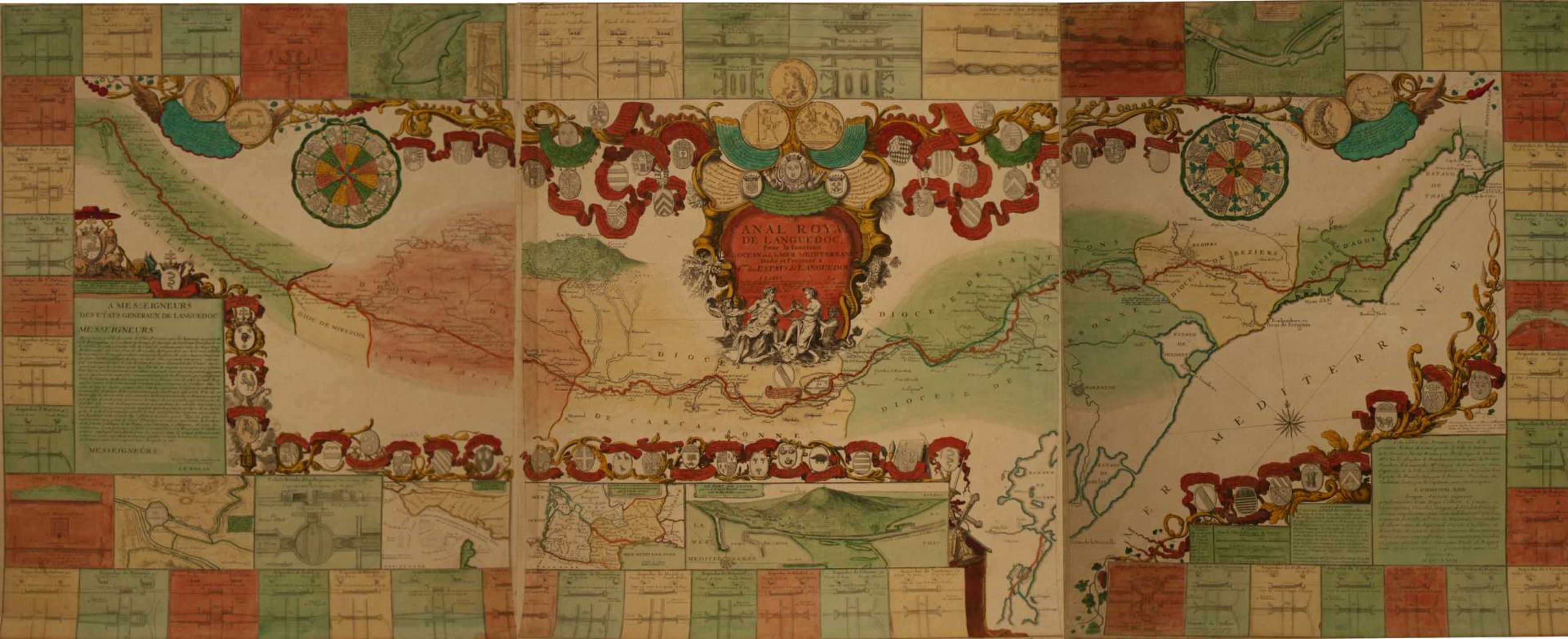
Watercolor map of the Canal du Midi in 3 parts: "Le canal royal de Languedoc pour la jonction de l'Océan et de la Méditerranée dédié et présenté à Mgrs des États de Languedoc" by Jean-Baptiste NOLIN (1657-1708), 1697 - Spectacular watercolor print marking a turning point in the rich production of maps and plans of the Canal Royal de Languedoc, as much for its quality of realization as for its high symbolic value. The engraver Jean-Baptiste Nolin distinguished himself in the production of maps, which earned him the title of geographer. This map was engraved in 1697, after the completion of the improvements (1687-1694) recommended by Vauban, thus celebrating the official completion of the work. Vauban proposed improvements to overcome the technical failures related to the silting of the canal, river flooding and water supply. It was the engineer Antoine de Niquet who built the masonry structures to isolate the numerous rivers that crossed the canal, as well as the spillways to regulate the water level. He built forty-nine aqueducts and canal bridges. On this map, around a rather rough plan of the Canal, are distributed plans and sections of the forty-four aqueducts of the Canal, nine plans of strategic places and exceptional works of art. There are also a number of coats of arms of the great men of Languedoc (governor of the province, intendant, officers of the States, members of the nobility and the clergy...) as well as reproductions of medals struck on the occasion of the solemn laying of the first stones of the construction site, in Toulouse and Sète. The logic of the accumulation of architectural and symbolic elements underlines the technical prowess of the Canal and celebrates, through this exceptional work, the glory of King Louis XIV and that of the States of Languedoc, which largely participated in the financing of the waterway. Title at the top, in a cartouche illustrated with allegorical figures, with a garland of shields bearing the arms of the lords of the lands affected by the Canal, with three medals bearing the effigy of Louis XIV. - At the bottom left, dedication and garland of shields with the arms of the bishops and archbishops of Languedoc. - At the bottom right, arms of the councilors of the States. - Around the map, in cartoons: 46 plans of aqueducts and locks, general map, particular maps of the entrance of the Garonne, of the Naudrouze basin, of the Orb passage and of the port of Cette and the St. Farriol reservoir. "Strictly speaking, the Canal du Midi refers to the initially realized part, from Toulouse to the Mediterranean, of the Canal des Deux-Mers project, a set of navigable waterways allowing to join the Mediterranean and the Atlantic: the Canal du Midi and the Garonne, more or less navigable between Toulouse and Bordeaux, then the Canal Latéral à la Garonne, built later, and the Gironde estuary after Bordeaux. It was the wheat trade that motivated its construction. Built from 1666 to 1681, under the reign of Louis XIV and under the supervision of Pierre-Paul Riquet, the Canal du Midi is one of the oldest canals in Europe still in operation (the prototype being the Briare Canal). The implementation of this work is closely linked to the question of river navigation in modern times. The challenge, taken up by Pierre-Paul Riquet, was to bring the water from the Black Mountain to the Naurouze threshold, the highest point of the route - Dimensions : 60 x 144 cm
Automatically translated by DeepL. The original version is the only legally valid version. To see the original version, switch to the French language.


